When you look at a map of the English Channel, the choice seems almost stupid. Why Normandy? If you were a betting man in 1944, you would’ve put your money on the Pas-de-Calais. It’s the shortest distance. You can basically see France from the white cliffs of Dover. Logic says you go where the water is narrowest so you can shuttle troops back and forth fast. But logic is exactly what the Allied planners—the guys in the COSSAC (Chief of Staff to the Supreme Allied Commander) office—were trying to subvert.
They chose Normandy because it was the "Goldilocks" zone of invasions.
Not too close to the heavy German 15th Army. Not too far from British air cover. It was just right, even if the "right" choice involved landing thousands of teenagers on a wide-open beach under heavy machine-gun fire. If you’ve ever wondered why was Normandy beach selected for D-Day, you have to understand that it wasn't just about the sand. It was about the ports, the tides, and a massive, multi-layered con job that kept Hitler looking the wrong way until it was too late.
The Pas-de-Calais Trap
The Germans weren't idiots. Rommel and Rundstedt knew an invasion was coming. They looked at the same maps as Eisenhower. The Pas-de-Calais was the most obvious landing spot. It offered the direct route to the heart of Germany. Because of this, the Germans turned it into a fortress. It was the most heavily defended stretch of coastline in the entire Atlantic Wall.
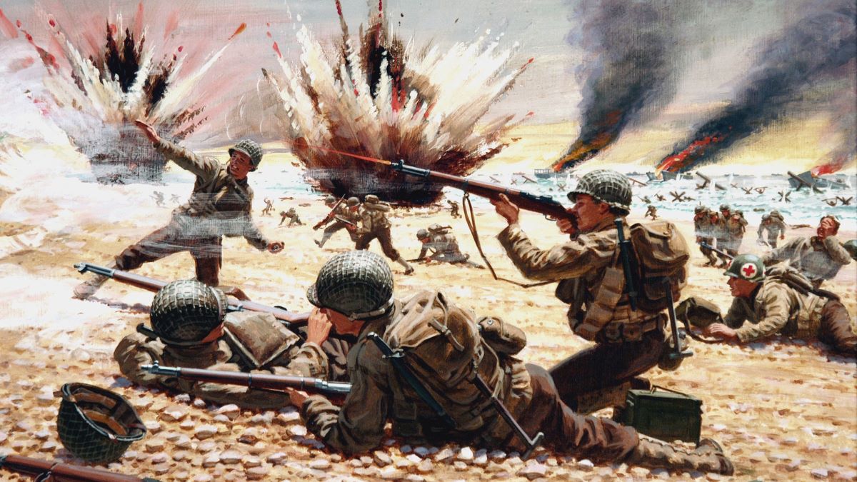
Landing there would have been a bloodbath that likely would have failed in the first three hours.
Planners like Lieutenant General Frederick Morgan looked at the Pas-de-Calais and saw a meat grinder. The beaches were narrow. The exits were tight. The German 15th Army was sitting right there, ready to pounce. If the Allies hit Calais, they were hitting the enemy at his strongest point. Normandy, by contrast, was defended by the 7th Army, which was considered "static" or second-rate compared to the units further north.
Logistics: The boring stuff that wins wars
Amateurs talk strategy; professionals talk logistics. This is a cliché for a reason. To win in France, the Allies didn't just need to land; they needed to stay. That meant they needed a port.
Normandy had Cherbourg.
It also had the potential for the Allies to capture the Brittany peninsula later. But here’s the kicker: Normandy’s beaches were huge. They were wide enough to land multiple divisions simultaneously. You couldn't do that at the other sites under consideration, like the Cotentin Peninsula (too marshy) or the Netherlands (too much flooding).
The Mulberry Factor
One of the weirdest reasons why Normandy beach was selected for D-Day was the "Mulberry" harbors. The Allies knew they wouldn't capture a major port like Cherbourg on Day 1. So, they decided to bring their own. These were massive, floating concrete harbors that they towed across the Channel. The geological makeup of the Normandy coast—specifically the shelter provided by the Calvados reef—made it the only place where these experimental harbors had a prayer of working.
Without the Mulberries, the Normandy choice falls apart. You can't feed an army of a million men via rowboats.
Air Cover and the Spitfire's Reach
Air power was the deciding factor. Air Marshal Leigh-Mallory was adamant: the invasion had to happen within the "umbrella" of Allied fighter planes based in England.
Spitfires and P-47 Thunderbolts had limited fuel. If the invasion moved too far west—say, to the Brittany coast—the planes would have about five minutes of "on-station" time before they had to fly back to England to refuel. That would leave the guys on the beach defenseless against the Luftwaffe. Normandy was at the absolute limit of effective air cover. It was the furthest south they could go while still keeping thousands of planes over the heads of the infantry.
The Great Bamboozle: Operation Fortitude
Honestly, the choice of Normandy only worked because the Allies convinced the Germans it wasn't Normandy. This is where the story gets kinda wild. They created a fake army group—the First U.S. Army Group (FUSAG)—under George S. Patton. They put him in Southeast England, right across from Calais.
They used inflatable tanks.
They used fake radio chatter.
They even used a double agent named Garbo to tell the Germans that Normandy was just a "diversion" and the real attack was coming at Calais later.
It worked so well that even after the paratroopers dropped into Normandy on June 6, Hitler held his tank divisions back in the Pas-de-Calais for weeks. He was convinced Normandy was a feint. By the time he realized the truth, the Allies had a foothold they couldn't be kicked off of.
Sand and Soil: The literal ground under their feet
You can't just drive a 30-ton tank onto any old beach. If the sand is too soft, the tank sinks. If the tide is too high, the obstacles kill the landing craft.
In the years leading up to 1944, the British actually sent "frogmen" on secret missions to Normandy. They would swim ashore at night, take soil samples, and swim back. They needed to know if the peat under the sand would support heavy vehicles. They even ran a competition in the newspapers asking for people's old holiday photos of the French coast. They used those vacation snaps to map out where the rocks were and where the sand was firm.
Normandy’s wide, firm sands at low tide were the only place that could support the sheer weight of the mechanized monster the Allies were bringing.
Weather and the Moon
The timing was as important as the location. They needed a full moon for the paratroopers to see their drop zones, but they also needed a "low tide at first light" so the engineers could see and destroy the German beach obstacles (like the "Hedgehogs" and "Rommel's Asparagus").
Those conditions only aligned a few days a month.
When you ask why was Normandy beach selected for D-Day, you have to realize it was a mathematical equation as much as a military one. The geography of the bay—the Baie de la Seine—created tidal patterns that were predictable enough for the Navy to manage, even if the weather turned sour (which it famously did, forcing Eisenhower to postpone from June 5 to June 6).
The "What If" factor
What if they had chosen elsewhere?
If they had gone to the Mediterranean, the mountain ranges of the Alps and the Balkans would have slowed them to a crawl. If they had gone to Norway, they’d have been too far from the heart of Germany.
Normandy offered a "gate" into the flat plains of Northern France. Once they broke through the "hedgerows" (the bocage), they could use their superiority in tanks and trucks to race toward Paris. It was the only spot that offered a balance of manageable defenses, logistical feasibility, and a clear path to victory.
What you should take away from this
The selection of Normandy wasn't a stroke of genius found in a single afternoon. It was the result of years of agonizing over tide tables, soil samples, and fuel gauges. It was the "least bad" option in a sea of terrible choices.
If you want to dive deeper into the reality of the landings, here is what you should do next:
- Visit the Mulberry Harbor remains at Arromanches: You can still see the concrete pylons today. It gives you a sense of the sheer scale of the logistical nightmare the Allies solved.
- Study the "Bocage" maps: Look at how the terrain immediately inland from the beaches nearly cost the Allies the war. The "why" of the beach selection is only half the story; the "how" of the breakout is where the real struggle lived.
- Research Juan Pujol García (Agent Garbo): To understand why Normandy worked, you have to understand the man who lied to Hitler's face and was believed.
The beaches were selected because they were the only place where the Allies could land enough men, under enough planes, with enough supplies, to actually stay. Everything else was just noise.